Flood zone building codes and requirements depend on a property’s FEMA map classification and the flood risk it represents. The Special Flood Hazard…
Flood zone building codes and requirements depend on a property’s FEMA map classification and the flood risk it represents. The Special Flood Hazard Area is tied to a flood with a 1% annual chance, and FEMA defines Base Flood Elevation as the height floodwaters are expected to reach during that event. The map classification helps determine which elevation and flood-resistant construction standards apply.
A flood map label does not tell the whole story. Flood zone building codes and requirements also depend on the structure and local floodplain rules. This article explains what FEMA zones mean, how flood probabilities relate to those classifications, and how maps inform construction standards in high-risk areas. You’ll also learn why elevation, foundation design, permits, and local rules matter when planning a home in a mapped flood hazard area.
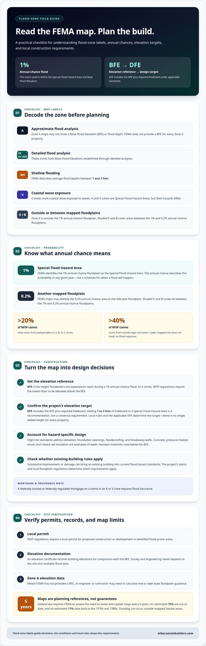
FEMA flood zones classify mapped flood hazards and help identify construction and insurance considerations. The Federal Emergency Management Agency defines Base Flood Elevation as the height floodwaters are expected to reach during a flood with a 1% annual chance in the United States. This elevation provides a reference point for planning a building’s lowest floor.
Base Flood Elevation, or BFE, differs from Design Flood Elevation, or DFE. DFE includes the BFE plus required freeboard, an added vertical allowance that varies with building risk category and applicable standards. For a Special Flood Hazard Area, adding 1 to 2 feet of freeboard is a recommendation, not a universal requirement. FEMA’s AH zones describe shallow flooding with average depths between one and three feet.
How high must a building’s lowest floor be above the BFE? In A zones, NFIP regulations require the lowest floor to be elevated above the BFE. The applicable DFE and local rules determine the project’s elevation target; there is no single added height for every property.
What permits, surveys, and elevation certificates are required to build in a flood zone? NFIP regulations require a local permit for proposed construction or development in identified flood-prone areas. An elevation certificate records building elevations for comparison with the BFE. Survey and engineering needs depend on the site and available flood data. FEMA does not provide a BFE for every Zone A property, so an engineer or contractor may need to calculate one or seek state floodplain guidance.
How much does flood zone-compliant construction typically cost? The price depends on site conditions, the elevation target, foundation design, materials, and engineering scope, and is provided after a quote request. Concrete, pressure-treated wood, and closed-cell insulation are examples of water-resistant materials used below the BFE.
How can a professional help appeal or request a FEMA Letter of Map Amendment? A professional can assess elevation and survey documentation, then prepare materials for a Letter of Map Amendment or Letter of Map Revision Based on Fill. For eligible flood insurance policies affected by a map update, premiums usually cannot increase more than 18% per year until reaching the full risk rate, according to the Federal Emergency Management Agency.
FEMA maps classify flood hazards by probability, location, and the detail available from flood studies. These classifications help communities shape floodplain regulations and guide building and insurance decisions.
FEMA flood zones identify mapped areas with different flood hazards and levels of analysis. Zone A uses approximate methods, so maps may not show a Base Flood Elevation or flood depth. AE and A1-A30 zones have Base Flood Elevations from detailed analyses; AH zones describe shallow flooding with average depths between one and three feet. FEMA defines the Base Flood Elevation as the height floodwaters are expected to reach during a flood with a 1% annual chance in the United States. V zones mark coastal areas exposed to waves. Zone X is outside the 1% annual-chance floodplain, while shaded X and B indicate another mapped risk category.
An annual-chance figure describes the probability of a flood occurring in any given year, not a schedule predicting when one will happen. FEMA identifies the 1% annual-chance floodplain as the Special Flood Hazard Area. Shaded X and B zones cover areas between the 1%- and 0.2%-annual-chance floodplains; FEMA maps may also identify the 0.2% annual-chance area as the 500-year floodplain. More than 20% of NFIP claims have come from policyholders in X, B, or C zones, showing that lower mapped risk does not mean no flood risk.
FEMA maps guide community floodplain management by showing where flood hazards may affect development and which regulations may apply. Federal law requires FEMA to assess the need to revise and update maps every 5 years. Maps have limitations: an estimated 75% are out of date, and an estimated 11% date back to the 1970s and 1980s. A map classification is therefore a planning reference, not a guarantee that flooding cannot occur elsewhere. For a building project, flood-aware home planning can help connect mapped risk with design decisions.
High-risk rules focus on elevation, flood-resistant design, and local approval. Requirements vary according to the mapped hazard and the building’s use.
High-risk areas include inland floodplains and coastal zones exposed to storm waves. FEMA A and V zones are Special Flood Hazard Areas, but their hazards differ: V zones face wave action, while inland A zones include river and other flood sources. NFIP minimum standards and I-Codes require new construction and qualifying existing buildings in flood hazard areas to be elevated above the depth associated with a flood with a 1% chance of occurring in a year. Design also addresses foundation openings, floodproofing, and breakaway walls.
Substantial improvement or damage can bring an existing building into the scope of current flood-hazard standards. NFIP minimum construction standards and the I-Codes require qualifying existing buildings to be elevated above the flood depth associated with the 1% annual-chance event. The project’s status and local floodplain regulations determine which requirements apply, so existing construction alone does not establish the standard for later work.
A federally backed or federally regulated mortgage on a home in an A or V zone requires flood insurance. However, high-risk boundaries don’t capture every claim: more than 40% of NFIP claims come from outside high-risk zones. A lower-risk map designation therefore doesn’t mean a property has no flood exposure.
Moderate-risk areas can include shallow flooding with average depths below 1 foot, sometimes in drainage areas smaller than 1 square mile. Zone X is outside the 1% annual-chance floodplain; shaded X areas have a different mapped risk from areas beyond that floodplain. Risk Rating 2.0 determines flood insurance rates using factors such as distance to water, foundation type, building height relative to BFE, historical claims, and replacement cost.
NFIP regulations require a local permit for proposed construction or development in identified flood-prone areas. Building without required approval risks unapproved work and local enforcement. Floodway construction faces strict limits: NFIP rules allow no more than a 1-foot increase in flood levels under the described circumstances. Local floodplain regulations may be more stringent, making early permit review important for proposed construction.
FEMA maps identify mapped hazards, while adopted building codes translate those classifications into construction standards. Understanding how flood zone building codes and requirements work together helps clarify design, permitting, and flood insurance decisions.
A professional determines mapped status by locating the property on FEMA flood maps and reviewing its classification. FEMA’s National Flood Hazard Layer covers approximately 90% of the U.S. population, making it a broad reference for identifying mapped flood hazards. A builder can compare the parcel location with the mapped boundary and elevation information, then account for map amendments that affect the designation. This step helps define which flood-related code provisions may apply.
To determine whether a property lies in a FEMA flood zone, a professional locates it on the applicable map and identifies its zone and mapped flood elevations. If an owner disputes a designation, a Letter of Map Amendment or Letter of Map Revision Based on Fill may provide a formal way to seek a map change.
Floodplain building codes vary because states adopt and modify model codes, while local regulations may set stricter standards. NFIP floodplain development criteria appear in 44 CFR §60.3, and the International Building Code addresses flood-hazard construction in Section 1612. Under Chapter 16, the IBC directs structures in flood zones to follow ASCE 24-14 guidelines. These frameworks establish a baseline, not necessarily the final local requirement.
California adopts the International Building Code as the California Building Code, with modifications. Local floodplain rules can add requirements beyond general building-code provisions, so the governing jurisdiction affects permit review and design. For example, the 2022 CBC and ASCE 24-14 define design flood elevation as Base Flood Elevation plus required freeboard. The required freeboard depends on the building’s risk category, so flood zone building codes and requirements must be considered alongside the adopted local standards.
FEMA’s map identifies the hazard, but the applicable state and local codes shape the construction response. Plan flood-aware home construction with the map classification and local code requirements in view.
OTBX Custom Builders, LLC helps connect flood-map information with practical planning for new homes. When you’re considering construction in a mapped hazard area, the zone, elevation targets, and local code requirements all influence design decisions. Bringing these factors into planning early can help clarify the home’s layout and construction approach.
With new home construction, custom homes, and stick-built homes, OTBX Custom Builders, LLC works with you on a plan shaped around your project’s requirements. Residential drafting and floor planning design services can support clear, coordinated plans. Start with a conversation about your property and the home you want to build. Contact OTBX Custom Builders, LLC to discuss your project.
A sound approach to flood zone building codes and requirements starts before the home’s layout is settled. Treat flood risk as a design input, not a detail to resolve after plans take shape. This gives you room to coordinate the property’s mapped conditions, the intended structure, and applicable construction standards from the outset.
For a new project, start with a focused conversation about the property and your building goals. OTBX Custom Builders can bring these considerations into the planning and construction process, grounding decisions in the site’s needs. Clear questions at the outset can help organize the path from initial plans to a buildable project.
Contact OTBX Custom Builders to discuss your project and its flood-zone considerations. With careful planning, you can move forward with greater clarity and a stronger foundation for the decisions ahead.
A professional builder should coordinate the mapped hazard, site elevations, and applicable local standards before finalizing the home’s design. These inputs shape floor height, foundation design, and the placement of utilities and enclosed spaces. For example, equipment below the design flood elevation may need to be elevated or floodproofed. Coordinating these decisions early helps align plans with flood-resistant construction needs.
Zone A is a FEMA flood-zone designation mapped using approximate methods, which means the map may not show a Base Flood Elevation or flood depth. That distinction affects planning because the elevation target may require additional site-specific analysis. Zone A differs from AE and A1-A30, where detailed analyses show Base Flood Elevations. A builder can use the zone information to identify the next design questions.
Flood hazard designations in a Special Flood Hazard Area, including A and V zones, can trigger flood-resistant construction standards. Exact requirements depend on the mapped hazard, building type, and local rules. A floodway designation also matters because construction there faces significant restrictions. A zone label is a starting point for identifying applicable permits and design standards, not a substitute for jurisdiction-specific requirements.
New construction in a flood hazard area must meet NFIP minimum construction standards and applicable building-code provisions. These standards generally require the building to be elevated above the flood depth associated with the 1% annual-chance event. Design provisions can address enclosed spaces, foundation openings, floodproofing, and breakaway walls. Local floodplain regulations may impose stricter requirements, so the governing rules affect the final design.
Flood-resistant design combines suitable materials with protection for equipment and foundation spaces. Concrete, pressure-treated wood, and closed-cell insulation are examples of water-resistant materials for areas below the Base Flood Elevation. Auxiliary structures and equipment must be elevated above the Design Flood Elevation or floodproofed when placed below the Base Flood Elevation. Enclosed spaces, such as crawl spaces, may also require flood vents.
Building without required approval risks unapproved work and local enforcement. NFIP regulations require a local permit for proposed construction or development in identified flood-prone areas.